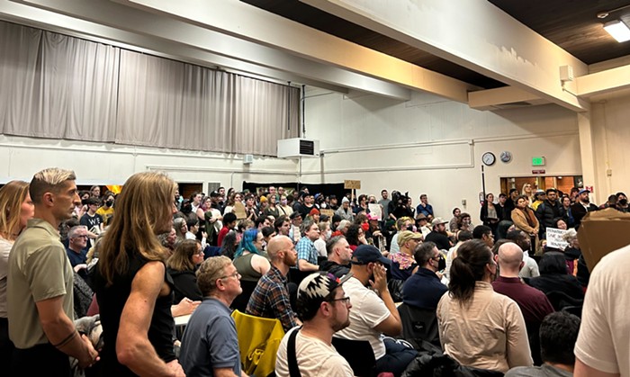
Last week, two of the five commissioners responsible for redrawing Seattle's voting boundaries flipped positions to keep Magnolia whole at the cost of moving most of Fremont into a different district, a decision that broke with community-sourced recommendations from the Redistricting Justice Coalition (RJC), a group of civil rights organizations that lobbies for equitable redistricting practices.
The commission’s August proposal originally divided Magnolia in half between District 6 and District 7, which cover the Ballard area and Downtown, respectively. Though that map aligned with RJC’s recommendations, it drew complaints from residents of Magnolia, a neighborhood that includes a large wealthy enclave and tends to vote conservative in local elections. Splitting the neighborhood, its residents worried, would dilute their voting power.
Commissioners said they never wanted to split Magnolia, but they couldn’t agree on a fair map to avoid it. That is, until a Ballard-based computer programmer came along and gave Commissioner Rory O’Sullivan an idea.
Both frustrated and inspired by the clusterfuck that was the state redistricting process, Scott Shawcroft decided to use his tech prowess to conduct analyses to advocate for fair city council district maps. The process for redrawing those maps plays out every decade to account for population changes. He used to work on the software that renders maps on Google Maps, so he’s used to fielding and fixing complaints about maps on a neighborhood level without messing up other areas.
“I think it’s my fault,” Shawcroft laughed when I asked if he suggested the Fremont-Magnolia swap to the commission.
Shawcroft didn’t set out to be the hero of the hundreds of Magnolia residents that flooded the public comment period to push to stay whole, and he really doesn’t want to be made out to be that hero either. He lives in Ballard, and he only travels to the area for Discovery Park. He just believes the redistricting process should seek to divide as few neighborhoods as possible.
To determine if a proposal divides a community, Shawcroft conducts a “split analysis,” which counts up the number of people a proposed map pushes outside of a given “primary district.” The boundaries of “primary districts” can be defined by City Clerk-designated neighborhoods, police beats, school district boundaries, and roads or major streets.
In response to the August map, Shawcroft looked at ways to reduce the number of splits across the City, paying special attention to City Clerk neighborhoods and elementary school boundaries. He came up with a few fixes, and then in public comment he “offhandedly” suggested that the commission put Magnolia in District 6, and then put what the commission defined as Fremont into District 7, since it had already drawn some funky boundaries for the Lenin statue's neighborhood.
O’Sullivan said Shawcroft’s comments stuck out to him as one of the first “specific suggestions” to keep Magnolia together. So, he ran with it.
On September 27, the commission passed an amendment to trade Magnolia for Fremont. The only commissioner to vote against the amendment, EJ Juárez, said “it was surprising to see an amendment so late in the process that deviated even further from the map with the most broad public support.”
Up until that point, O’Sullivan and Commissioner Neelima Shah had stuck close to the recommendations of the Redistricting Justice Coalition, whose proposed map would split Magnolia in two.
But O’Sullivan said his amendment did not represent a pivot away from the “invaluable” feedback from the community coalition.
“I developed an amendment based on Mr. Shawcroft’s suggestion because it aligns with the values expressed by the Redistricting Justice for Seattle Coalition, takes into consideration the decisions already made by the Seattle Redistricting Commission, and does a better job of ensuring that residents are in the same district as the majority of their neighborhood than previous maps considered by the commission,” O’Sullivan wrote in an email.
Shah echoed O’Sullivan’s emphasis on keeping neighborhoods whole. She called the commission a “group of do-gooders trying [their] best” to listen to everyone. She also noted that the new map reunited Eastlake.
While happy to have been helpful, Shawcroft said he’s just one person with a computer. His suggestions, he added, should be taken with a grain of salt–except, perhaps, for his suggestion that the commission should continue listening to the Redistricting Justice Coalition and, now, to Fremont residents.
The change really only shifted concerns from Magnolia residents (and probably former state Senator Rueven Carlyle and the Magnolia Chamber of Commerce, according to commenters from the Redistricting Justice Coalition), to Fremont residents. Some Fremont residents argued the new map breaks rules to honor waterways, as the Lake Washington Ship Canal separates Fremont from the rest of D7. They also lament that the draft splits Fremont into three different council districts, rather than two like in previous iterations. (Lol, more like THREE-mont.)
Shah said this amendment is simply the commission “exploring an option,” and everything is still subject to change. In fact, on Tuesday morning the commission discussed options to split Magnolia again to partially restore Fremont.
Concerned residents from Three-mont can bug the commission at the next public forum at City Hall on Saturday, October 8, or online.
However, Showcraft said that all maps on the redistricting commission's table aren’t so different from one another in practice at this point, and that they’re all “fine.” In his mind, a “good” map would “cause voting patterns that match the voting patterns of the City as a whole.” Based on this criteria, he looked at the results of nine races, all with close results in 2020 and 2021. He found that whether the City adopted the Redistricting Justice Coalition's map, the August draft that splits Magnolia, or the September Three-mont draft, the results of those nine elections would have been the same.